
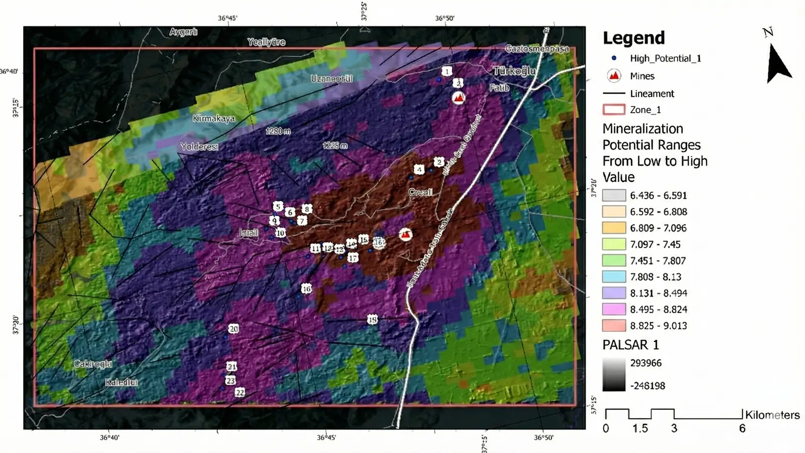
The Payas–İslahiye study addressed a regional prioritization question: how can scattered remote-sensing and geological evidence be organized into a short list of areas for field verification?
The public summary covers approximately 120 km² across four ranked zones. It is presented as a screening and decision-support study. It is not a deposit claim or a substitute for ground investigation.
The exploration decision
The terrain is geologically complex and includes areas where vegetation and surface conditions limit direct observation. The objective was not to declare new mineralization from imagery. It was to identify where a field team should investigate first and to preserve the reasoning behind that ranking.
The working question was:
Which areas combine the strongest available bauxite-relevant evidence, and what should be checked on the ground to test the interpretation?
Evidence stack
The workflow brought together:
- Landsat multispectral observations.
- Relevant ASTER archive information.
- PALSAR-2 radar-derived terrain and structural context.
- Elevation and geomorphological interpretation.
- Regional geological context.
- Known evidence used as context rather than as automatic proof.
Each source contributed a different observation. Spectral evidence was evaluated alongside terrain and geological plausibility, reducing dependence on a single proxy.
How the ranking was constructed
The study followed four decision stages:
- Frame the AOI and bauxite thesis. Define the regional setting, expected surface controls, data quality, and field decision.
- Prepare comparable evidence layers. Screen acquisitions, align datasets, derive relevant features, and document exclusions.
- Rank zones with visible rationale. Evaluate areas against the evidence stack and retain the main drivers and limitations.
- Package field checks. Translate ranked zones into a practical sequence for observation, mapping, and sampling.
Result
The approved public summary records:
- Approximately 120 km² evaluated across the selected regional setting.
- Four ranked zones for field verification.
- A multi-sensor rationale combining radar, multispectral, terrain, and geological evidence.
- GIS-ready priorities designed for technical review and field planning.
The ranking is intentionally expressed as zones rather than false point precision. Within each area, subsequent work should test the geological and geomorphological interpretation before the target is advanced.
What the field team should test
A field-verification program can examine:
- Parent lithology and weathering profile.
- Surface exposure versus transported or disturbed material.
- Iron-rich, clay-rich, and carbonate-related responses and their geological cause.
- Terrain position, drainage, preservation, and erosion.
- Structural or stratigraphic controls.
- Geochemistry and mineralogy from representative samples.
Evidence that contradicts the bauxite model should downgrade a zone even if its remote-sensing response is strong.
Limitations
The study does not establish:
- The presence of an economic deposit.
- Grade, thickness, continuity, or tonnage.
- Metallurgical characteristics.
- A mineral resource or reserve.
- Compliance with JORC, NI 43-101, or another reporting code.
Vegetation, archive limitations, terrain effects, mixed pixels, and non-unique surface responses remain possible sources of uncertainty.
Decision value
The deliverable is a defensible starting sequence: four areas, their main evidence drivers, their known limitations, and the observations needed to decide whether each should advance.
That is the intended role of remote intelligence in early exploration—focus the next field move while making the basis for that focus inspectable.